We begin to get our "sea legs"
Saturday,
10/23/04, 11:50 am.
At anchor in Oyster Bay, FL, 6 nautical miles inside
the Everglades
25° 19.6'N, 81° 04.2'W
We are really excited
to be where we are right now, both physically and emotionally. Physically
we are 6 miles deep into the Everglades, a place we had hoped to visit
but had no certainty we could accomplish, because the charts show only
4 feet of depth in this "bay" (actually a brackish lagoon behind several
miles of mangrove islands), Wind Song is 3' 6" deep loaded as she is,
the chart is old, and in large shallow areas tenuously connected to tides
the depth can vary with weather conditions. Emotionally, we are feeling
much more like the cruisers we once were as we have gotten the boat basically
working, have been through a few bits of weather, have accomplished our
first overnight passage, and have sailed and anchored a few times. We're
starting to trust the boat in this new environment, and we're starting
to trust ourselves.
Last you heard, we were in Blackburn Bay in the western Florida
Intracoastal Waterway (ICW). (This is to distinguish from the Atlantic
ICW which runs from Miami, FL to Norfolk, VA, and which we'll traverse next year for the second
time in our lives.) We took another hitch south, though Charlotte Sound,
past Boca Grande ("big mouth" in Spanish), a large opening to the Gulf
of Mexico, and down to a quiet anchorage just west of Useppa Key with
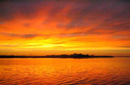
a view west across the ICW to Cabbage Key. The weather continued hot,
fair, and mild, with scattered thunderstorms over the area that produced
spectacular sunsets, as Lynn views below.
We hung out at anchor for two "lay days" while we worked some
more on Wind Song's sailing gear and storage arrangements, and
Tania's schoolwork setup, then we motored our final southbound ICW
leg down Pine Island Sound to an anchorage on the shoal-bound west
side of Kitchel Key, just a mile north and in direct sight of the Sanibel
Causeway Bridge (near Fort Myers, FL), beyond which lay the Gulf of Mexico
and the southern third of Florida's west coast.
Our next intended stop was an inlet into the Ten Thousand
Islands called West Pass, which lies east of Cape Romano and near
the northern extremities of Everglades National Monument. Since this
objective lay 64 nautical miles (nmi) away, and we wanted to sail if
we could, and Wind Song will reliably travel only 4-5 knots (nmi/hr)
under sail in mild breezes, we knew the passage would take 13-16 hours.
And since for safety (visibility) reasons we needed to be making landfall
no later than about 3 pm, we had to leave our anchorage no later than
11 pm. At the time it was 3 pm, and Tania was still doing schoolwork,
as she has been doing maniacally these days in an attempt to catch up
and be back on schedule by the end of this month, before we leave the
US. One other logistical consideration: we generally have stood 3 hour
watches at night at sea, which means 3 hours on, 3 hours off (hopefully
asleep), twice per night. In this case, we planned to give Tania a school-related
exemption for one of her watches, and since Lynn is not yet as familiar with Wind Song as
she once was with Daybreak, it became clear that Lane would
have to be on call at a moment's notice. This led Lane to decide that,
if he was going to spend the entire night on deck, he'd rather start immediately.
Accordingly, he and Roxanne spent the next two hours preparing
Wind Song for sea, and we raised anchor at 5:15 pm and transited
the Sanibel Causeway Bascule Bridge at 6 pm. Since we did not want
to arrive off West Pass until dawn (7 am EDT), we sailed under mainsail
only to keep our speed around 4.5 knots. Later on we shifted to motor
as the wind diminished, and when it re-arose later on we elected to stay
with the motor because Lynn was due to come on watch without Tania,
and a turn to windward was coming up in an hour, and Lane
was by this time dead on his feet, and Lynn pathologically loathes
wind. (Why is she sailing? Well, it may have something to do with her
being married to Lane.)
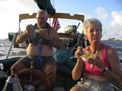
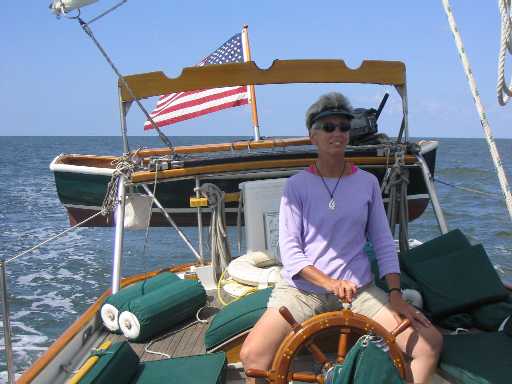
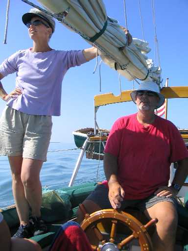
(below left) Caught
in the act by a shutterbug daughter: macaroni and cheese with bacon
bits for dinner,
just south of Sanibel
Causeway. The buildings at the right are on Punta Rassa, just east
of the bridge,
which is behind Lane.
BTW, that thing hanging around Lane's neck is a safety harness and tether
(for night or storm sailing)
with a water-activated inflatable
lifejacket attached.
Note that when comfortably
clad for cruising in the tropics, one's adipose condition is difficult
to disguise.
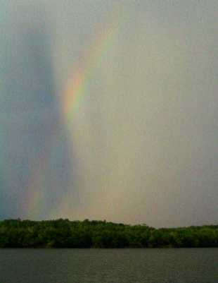
(below right) A faint rainbow near
sunset presages a violent cloudburst about to roll down West Pass like a freight train.
The rain comes down
so hard, the first two feet of air above the ocean turns white with
spray splashing up from the impact.
So the passage was completed under power. We arrived at West
Pass right after dawn and made our way 2 miles up the inlet to an anchorage
in 8 feet of half-salty water and half a knot of current out of the
Pass. We were immediately visited by an Everglades National Monument
ranger who was whizzing by in his center-console speedboat on his morning
rounds. He cordially read us the minimal list of rules for visiting yachts,
we shared our cruising plans and backstory with him and gave him our web
site address, he left, and we all went to sleep.
We spent the next day on small jobs around the boat while
Tania did schoolwork, and as the heat of the day waxed, we dove off
the boat, hung onto the anchor chain, and let the current bathe our
bodies in (relative) coolness. We got our comeuppance around sunset
as a violent thunderstorm hit us with rain and 20-25 knot winds, blowing
two of our (inadequately secured) cockpit cushions overboard. Lane,
after checking to make sure the anchor was holding in the gusts, dove
in to retrieve the cushions before they got too far away, then hung onto
a safety line Tania had prepared for him as Roxanne got the boarding ladder
deployed for his recovery. "No harm, no foul", as Chick Hearn used to
say.
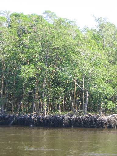
The Ten Thousand Islands are uniformly vegetated by "relatively"
immature mangroves, say 20-25 feet high. These plants are self-propagating
in that they not only reproduce, they also make new land for themselves
to grow on. Mangroves spread in two ways: by dropping seed pods that
float to new shallows and take root, and by dropping numerous long "root
vines" from branches that overhang shallow water, that grow downward to
take root in a few inches of water, thus allowing the plant to "creep"
and cover more ground. As this latter process progresses, the resulting
large areas of tangled roots trap silt that forms new soil, thus expanding
the land.
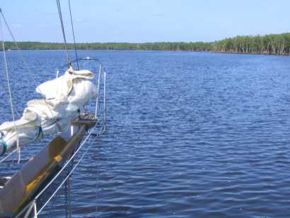
The next day we had a delightful sail another 38 miles south
to Little Shark River, on a full-sail beam reach (wind perpendicular
to the boat's centerline), then skimming across the shallows near the
inlet at over six knots with less than a foot of water under the keel.
We dropped sail right in the mouth of the river, then began a fascinating
motor trip through a veritable Amazonian wilderness. We had visions,
but no certainty, of making it all the way to Oyster Bay, the first of
two inland Everglade "lakes", respectively one by five miles and roughly
five by seven miles in extent. We reached Oyster Bay and managed to cross
it to an island marking its eastern shore by skating across a mile of mud
flats with our centerboard up and barely a foot under our keel. An accidental
grounding would have been ill-advised, because, having climbed up a couple
of feet in altitude over the 7-mile length of the river, there was very
little tidal action available to assist a stricken vessel off the mud.
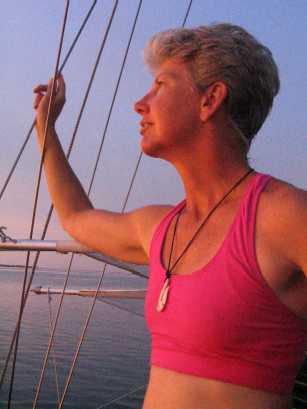
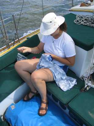
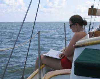
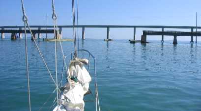
(below left)
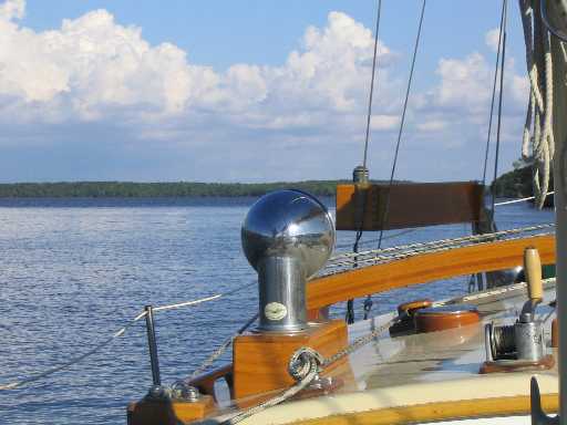
Lynn steers Wind Song on a delightful sail from West
Pass to Little Shark River, southwestern Florida, while
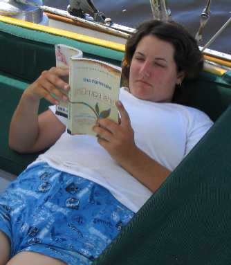
(below right) Roxanne finishes
sewing a new pair of pants for herself, and
(bottom left) Tania studies for
her Political Behavior class under the shade of the mainsail.
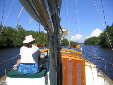
(bottom right) Roxanne in prime spectating
position as we navigate up the Little Shark River to Oyster Bay
A mature mangrove forest: 75 feet high, resting
on several feet of tangled roots over a brackish estuary.
Land? What land? You can't tell land from
tree roots.
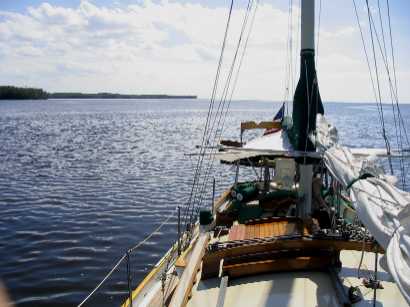
We make it to Oyster Bay!
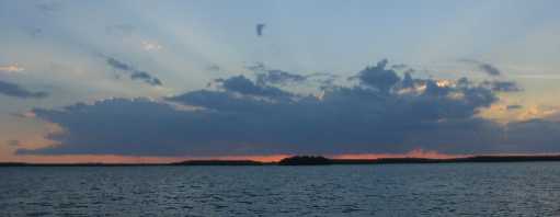
Afternoon thunderclouds darken the western
horizon from Oyster Bay
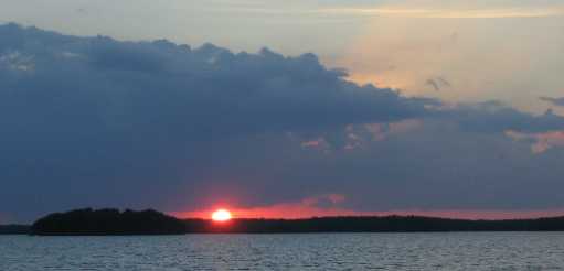
A beautiful sunset, but only until . . . the
mosquitoes arrive. Gaaah!
Which brings us to today, which we are taking as a lay day
before departing tomorrow for the mouth of the river and then Monday
the daysail to Marathon, FL, in the middle of the Keys. The chores and
shopping lists for Marathon are daunting, so we've allowed ourselves
nearly a week there. And then -- the Bahamas!
~~~~~~~~~~~~~~~~~~~~~~~~~~~~~~~~
Tuesday, 10/26/04,
6:09 pm
At anchor in Boot Key Harbor, FL, adjacent to the town
of Marathon
24° 42.3'N, 81° 06.0'W
We motored most
of the way from Little Shark River to Marathon in a slick calm and intense
heat under a cloudless sky that impeded the sun not one whit. This stretch
of Florida Bay was pocked by literally thousands of crab traps each connected
to a float by a piece of (floating) polypropylene line, a horrendous minefield
for propellers requiring constant vigilance and avoidance maneuvers for the
entire 7 hours. This process was compicated by a 1 knot westerly cross current
that set Wind Song down sideways onto the floats to starboard, requiring
the helmsman to steer too close for comfort to the floats on the port side
in order to maintain adequate clearance to starboard. The margin for error
was often no more than a few feet, which, to a novice helmsperson (Roxanne),
proved to be inadequate for her level of skill . . . twice.
The first time, Lane was maintaining watch from the bow, saw Wind
Song broadsiding the float, and yelled to Roxanne to shift to neutral,
which she did, too late for the prop to miss the line but in time to avoid
wrapping it on the shaft. We ended up slowly dragging the trap downcurrent.
We picked up the line with a boathook, cut it, and Lane dove over to remove
the offending float and its remaining tail of line. Of course, this took
place miles from land, with the boat anchored because otherwise she'd
be drifting through this minefield collecting more traps, which meant Lane
would be swept away by the current unless tethered to Wind Song.
So that's what we did. We were underway again in 30 minutes.
The second time, again on Roxanne's turn at the helm, we were not
so lucky. Lane saw it coming again but not soon enough, and our propeller
wrapped the trap line but good. The boathook trick did not work this time,
so Lane tethered up again, dove, and cut the line, which freed Wind
Song to drift. Roxanne and Lynn got the anchor down, the boat rounded
up into the current, and in several dives Lane got all the remaining line
off the shaft and prop blades. For this purpose he used a brand new, razor
sharp Kershaw "Leek" knife that he had received as a gift from a colleague
of his at Northrop Grumman, Jim Klein, that could be deployed with one hand
while in the water. Thank you, Jim! This knife has its uses!
We came into Marathon, fueled and watered up -- we were nearly empty
of water -- and entered the harbor to look for an anchoring spot. While
in the process, we were tailed by an old fellow in a fiberglass runabout
that said "T/T Nomad" on the side. This means "Tender to the vessel Nomad",
which was the largest yacht in the harbor, a brand new 60 foot Defever
trawler with "Aspen, CO" as a hailing port. His name was Pete, and it turned
out he'd been a sailor/cruiser most of his life until he "got too old for
sailing", and he bought Nomad. Obviously an astute judge of sailboats
(heh heh), he recognized Wind Song as a particularly lovely and
interesting vessel (we suppose), had decided to invite us over to Nomad
for cocktails, and he was alongside to issue this invitation as soon
as our anchor was secure.
We naturally accepted with alacrity and jumped into his very substantial
"dinghy" for the ride over to Nomad, where we met his delightful
wife Carol and embarked on a wonderful two hours or so with these folks
on a boat that was nicer than our condo back home -- and seemingly almost
as big. Cold soft drinks! Unlimited ice! Chilled Chardonnay and slightly
sub-ambient Merlot (because Florida ambient is, after all, properly too warm
for red wine).
Pete and Carol were cruising in company with friends of theirs, Ray
and Paula from Texas, on a 40 foot trawler named Sandpiper,
and they were due to show up for dinner aboard Nomad, so we got
to meet them too. Ray immediately made big points with Lane by recognizing
Wind Song as a "bugeye" design (more info here), and Paula was an effervescent soul.
We returned to Wind Song happy, and with Lane tipsy enough to promise
Lynn that someday they would, indeed, own and cruise together on
a motor yacht -- probably not as large as Nomad, but with comfort,
security, amenities, and, most important to Lynn, a substantial immunity
to wind, which, as I mentioned earlier, Lynn loathes. Sometime the next morning
Lynn figured out that Lane meant it.
Marathon stretches over a three mile length of US Highway 1, and
today we walked about half of it, visiting along the way the local public
library, where we checked our email, then West Marine Products, where
we bought a few boat odds and ends, then a Cuban restaurant for lunch (recommended
to us by the West Marine cashier), then Home Depot for some more boat-related
stuff, and finally a mini-mart for ice cream!
For $20 we are landing our dinghy for a week at the Marathon City
Marina, which also offers a laundromat, showers, a mailing address, a "TV
lounge" (a cubicle with a chair and a TV), a lending library, water for
Wind Song, local knowledge, and cold soft drinks! A civilized arrangement,
at least as low-rent sailboat cruising goes. This is all housed in a ratty
old warehouse run by a martinet cop-wannabee "dockmaster" whose first words
to us were a stentorian lecture on the legal requirement to carry life jackets
in our dinghy, and how by god we could just go back and get some before
thinking we were gonna land on his dock. By the way, you should understand
that the Marathon City
Marina does not actually have any docks or slips. It does have some
moorings.
Along those lines, we were also visited this evening by "officer Johnson",
who admonished us that we must show an anchor light from sunset to sunrise
-- which of course we know, but we usually don't turn it on until our house
lights are off, to save battery power. What struck us, though, was that
this admonition came from a guy who was intentionally running around Boot
Key Harbor -- a busy place full of anchored boats and small dinghies making
their way hither and thither -- with his running lights off. In order
to "sneak up on the bad guys". What the latter could be doing, we can't
imagine.
Speaking of "civilized", we've also arranged to, ahem, rent a
car on Thursday, when we'll do our final shopping before jumping
to the Bahamas. And with our arrangement with the City Marina, we can
bring Wind Song alongside the city quay to top off water and schlepp
groceries the easy way, rather than ferrying them by dinghy.
If that does sound civilized, then for those of you unfamiliar
with cruising on a cramped sailboat, Lynn says "Think of it as four people
living in a diner booth" -- in sick heat, with no AC, no cold drinks,
no waitress, and no cook. And it moves ALL the time,
and weather threatens it, and it's costing us in low 6 figures for the privilege.
And we're just nuts enough to think all that is a good idea!
~~~~~~~~~~~~~~~~~~~~~~~~~~~~~~~~~
A message from Tania:
A special shout-out to all mes amies in the circle! Emua, nita/phil,
Willy Wally and Cathy, Lili, Cacie-bacie, Abush, Jaime, Guy, Joshie,
Pauldo, the real Eydie Moh and anyone I forgot! I love you all!!! Also
a great big "Hi!" to the greatest geography teacher ever, Mr. Harris and
all my freshmen in Period 3. I love the mints! Important News Update:
I will be coming back to El Segundo for AP tests and the SAT around May
2nd, so I'll see all you guys then.
~~~~~~~~~~~~~~~~~~~~~~~~~~~~~~~~
A message from Roxanne:
I'd like to begin by mentioning the unforeseen difficulty of writing
for an unknown audience. I mean, I know some of the people reading
this, and they're all different. It's like I'm speaking in front of all
of the people I know in my life, and they're all hearing the same thing.
Which is weird. You wouldn't talk the same way in front of your grandmother
that you would in front of your friends, right? Right. That's my problem
here.
I would like to write, though. Don't worry. It'll be fun. Probably
painless, too.
Moi aussi je voudrais un shout-out, to my superduper buddies Christina,
Joyce, Jessica and Katharine, aka Ace, Oyster, Viking Kween and Sweet n'
Pretty Katarina. Je vous aime bien! Portez-vous saines!
~~~~~~~~~~~~~~~~~~~~~~~~~~~~~~~~
Friday, 10/29/04, 2:41
pm
Still at anchor in Boot Key Harbor
Time to finish up here and move on. According to our itinerary, we're
supposed to leave Sunday for Long Key Bight, a protected cove and jumping
off point for the Bahamas about 45 miles east of here, and then a couple
of jumps: first, the 100 mile crossing of the Gulf Stream to South Riding
Rocks, an exposed perch on the western edge of the Great Bahama Bank, then
65 miles across the Bank to our first Bahamas anchorage, SE of Joulter Keys,
which is just north of the northern end of Andros Island. The latter must
be done in daylight, so unless conditions are very calm it may have to be
two day-hops, with an utterly exposed anchorage in the middle of frigging
nowhere between them.
We did rent the car yesterday (just turned it in this morning), and
boy was that the right thing to do. The girls stayed at the boat, where
Tania did schoolwork and Roxanne read while Lynn and Lane did a grocery
run, filled a propane tank, and made a final stop at West Marine Products.
We loaded everything into the dinghy, leaving just enough room for Lane,
who ferried it out to Wind Song, offloaded it, picked up the girls,
and headed back to shore. Then off we drove in the mid-afternoon for Key
West.
It is odd that there is virtually no Halloween activity down here in
the Keys, except . . . well, Key West has something called Fantasy Fest
on that weekend. Actually, it starts out slow early in the week and gets
totally nuts by the weekend, a Mardi-Gras sort of thing marked by lots
of people in very skimpy clothing and a lot of body paint and other
decorations parading up and down Duval St -- the main "drag", as it were.
"Skimpy" here means "a G-string", irrespective of gender. Not included
among the prerequisites for such display were body type or condition,
sexual preference, or age, so . . . if it was ambulatory, it was on Duval
St, essentially naked. "A Chorus Line" it was *not*. Some of these images
will stay with us for awhile.
We walked all of Duval sightseeing and souvenir shopping, until it
was time for some sort of dinner. By this time the bars were looking pretty
scary, so we were ready to punt and go eat at Denny's (there is one on
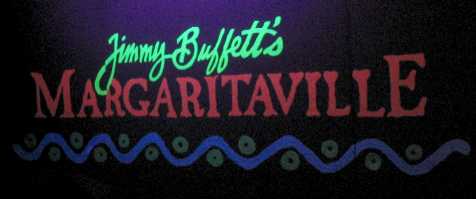
Duval) when we passed by Jimmy Buffet's Margaritaville bar-restaurant-night
club, which was surprisingly nice-looking, had a decent menu at reasonable
prices, and was virtually empty. We stopped in, and were glad we
did.
After dinner it was time to leave central Duval St, so we got in the
car and, on our way out of town, swung north to the Gulf side of Key West
where things were seriously cranking up. It was sunset, the party was spreading
across town and intensifying, and it was only Thursday. Imagine Saturday
and Sunday! We dodged a zillion pedestrians not one of whom was paying any
attention to the traffic signals, and drove "home", which means Wind
Song for the next 9 months. We're pretty used to her now.
Today we're cleaning up loose ends -- mail, bank stuff, etc. -- and
tomorrow we'll run one or two final errands. Then, weather permitting, we'll
start out for the islands. Right now the forecast is for northeasterly to
easterly winds 10-15 knots, which is pretty close to "on the nose" in cruiser
parlance. The Gulf Stream will probably be pretty lumpy but not prohibitive,
and we expect we'll get across OK. Once on the Great Bahama Bank we don't
expect too much trouble.
Wind Song at anchor in Oyster Bay, where it
was hot, muggy, and buggy.
Roxanne prepares to support Tania in her schoolwork
by reading The Namesake, on which Tania must write an essay in December.
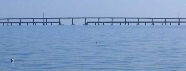
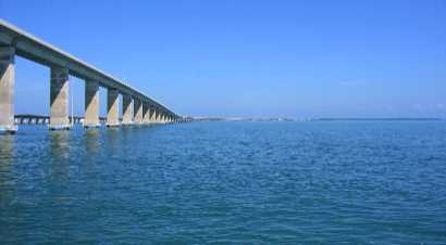
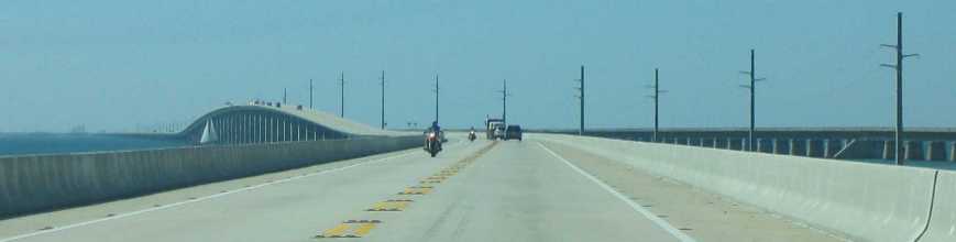
We approach Seven Mile Bridge at Moser Channel on the
Overseas Highway (US1 to Key West).
Note the crab trap floats in the foreground. Four are visible here.
At higher resolution one can count nine in the photo,
and this was about a tenth of their concentration further north in
Florida Bay.
Lynn and Lane navigate between crab trap floats with
an intensity not often necessary when motoring across a flat calm.
Underneath the Moser Bridge (65 foot vertical clearance), then a quick
left turn and the final two miles to Boot Key Harbor.
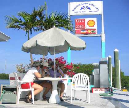
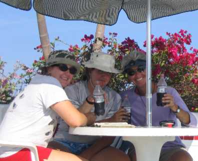
We stop for fuel and water at the first fuel dock we
espy, and gorge on ice-cold Diet Cokes in the shade of an umbrella.
We coulda stayed there all day!
Three days later we watch another sailboat emerge from
beneath Moser Bridge as we drive west out of Marathon for Key West.
(That's the "old road" over to the right.)
The fluourescent black-lit stage backdrop in Jimmy
Buffett's Margaritaville nightclub . . .
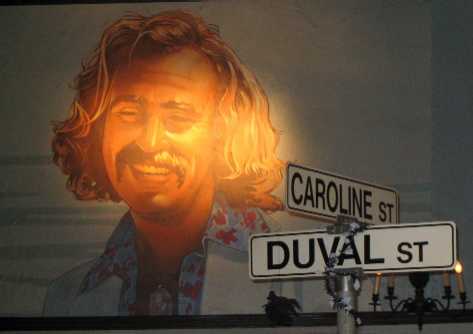
. . . and a giant portrait of the man himself,
spotlit on the wall, behind street signs apparently stolen from the nearby
intersection.
Since we're so close
to being done with Florida, we thought this would be a good place
to show you our entire route to date,
superimposed on a MODIS image of Florida from space. (Recall that Lane
worked for the past 3.5 years with Raytheon Santa Barbara Remote Sensing,
which built the two MODIS instruments that fly on the two NASA Earth Observing
System satellites named Terra and Aqua.)