We are on the back side of Great Exuma Island at last! And like many things in cruising, it didn't happen like we expected -- in fact, it didn't happen until we gave up on having it happen like we expected, which was to go east from Elizabeth Harbor to Hog Cay Cut, then south through the cut to the back side.
We've had to face this before: that what we have in mind to do is so overconstrained by conflicting logistical requirements that there doesn't ever seem to be a time when everything that needs to be favorable is favorable at once -- and where Hog Cay Cut is concerned, not one of the constraints could be relaxed, because it's a dangerous place. In the end, the constraints on just getting out of Elizabeth Harbour were so conflicted that we decided to simply take any opportunity to leave that presented itself and then have at least three options on which way to go then.
Based on our experience in 1994, we had no inkling that Elizabeth Harbour is often closed at both ends by swell alone, let alone wind. This area of Great Exuma Island is open to NE swells from the open Atlantic through a gap 25 miles wide about 45 miles to the NE, and those swells have been running 9-13 feet for weeks due to the winter NE trade winds, which dominate east of here, where the fronts off North America do not reach. So even when the winds die down in Georgetown between cold fronts, the swell keeps on pumping. There are occasional breaks in that swell, but if these coincide with 20-30 knot post-front northerly winds, then the exits are plagued by local wind waves that also close the harbour -- plus the steep short seas outside that are no fun at all, not to mention the winds themselves.
So when the winds died down to 10-15 knots with "only" 6-9 foot swells, we left the harbour by the only navigable exit -- the NW exit -- and turned in the direction most downwind -- NW -- because the wind had gone from NE to E in the night, thus removing the option of heading SE to Hog Cay Cut for two reasons: 1) it was upwind, and 2) having left by the NW exit we couldn't get there in time for high tide at 0830 that morning (2/9). We went instead to Rat Cay Cut 20 miles the other way, which is wider, deeper, less intricate, and far more forgiving than Hog Cay Cut. As it was we hit the cut at max ebb current, so we had to surf in on four foot tidal bore waves at flank speed, which was exciting. We anchored S of Rat Cay in the tidal channel -- 20 feet deep and excellent holding in firm white sand, with only modest 1.5 knot currents and good wind protection. No pictures -- sorry.
We only stayed there one night, again for logistical reasons: We only have 9 days of water so we have to move fast if we're going to see much back here, we had a new front scheduled to appear last night for which we needed W-NW protection, we needed mild weather, good visibility, and a high tide to negotiate Pudding Cut through the Brigantine Cays, right behind the NW tip of the island we needed to get behind to reach the "back side".
And the weather was absolutely perfect, which in this case means a dead flat calm, a cloudless sky, and the sun not in front of us. This trip was not only uneventful but spectacularly beautiful, all in crystal clear water 10 feet deep over clean sand bottom. Heaven.
23° 31.63'N, 75°
53.06' W
Open roadstead off Lovely Cove Cay
February 11, 2005
We decided to move down here, 9 miles, though by now we are wondering why. We came down on a beam reach under mainsail alone (about half our sail area) doing 6-8 knots in 20-25 knots of wind. We thought the wind was going to veer NE but it didn't, staying in the N, which made our intended anchorage a lee shore, on top of which the northerly wind has blown enough water out of this area to reduce water depth more than a foot -- and on this side of the island the bottom shelves so slowly we'd have to move roughly ten miles west to get that foot back. At the moment we think we are almost at low tide, we are a mile from the nearest land, we are still in 18-20 knots of wind, we are riding to 100 feet of chain plus a 5/8" nylon snubber in 4'6" of water, we are in a foot of wind chop, the boat is bouncing around, and we have an average of one foot of water under our keel. It is a bit distracting, especially since the subject at hand is how perfectly quiet yesterday was. Hard to concentrate.
But here goes. Picture time.
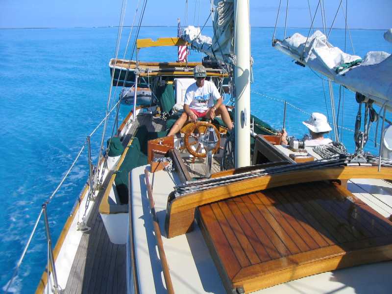
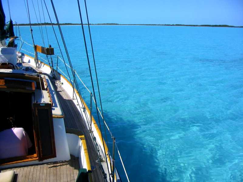
Lynn at the helm while
Roxanne reads, coming south toward Rocky Point and The Hook from Pudding
Cut. Water depth ten feet. These colors are straight out of the camera unedited,
exactly how it really looked.
Lane went out on the
bowsprit, reached down with the camera, and got this one.
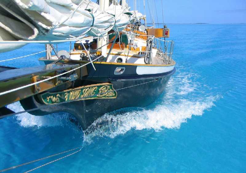
(below left)
It doesn't get much prettier than this.
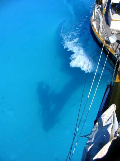
(below right)
Oh, wait. Yes, it does.
 __
__
Is this a swimming
pool, or the ocean?
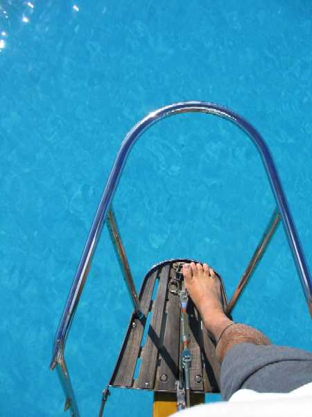
At anchor under the
east lee of The Hook. Those blotches under the water are live sponges. As
the tide fell we moved our anchor back about 200 feet to avoid damaging them
with our keel, which got within six inches of the bottom at low tide.
Which brings us to here, where there is not much to see, because the land is far away and not readily photographed, and the bottom, though not at all far away (8 pm, just measured the depth at 4' 3", nine inches under the keel, should make it. Fortunately the chop has eased, so we're not dancing as much), is also not photographable because the water is now churned up by the wind and chop. The bottom is what Bahamians call "mud" -- pure white calcareous mud. If there were also sea grass, we'd probably find conchs here. Conchs eat the grass. But in the present conditions we'd never see them either. Might hit them with our keel . . .
The prevailing drama aboard at the moment, however, has nothing to do with shallows or wind or water clarity, it has to do with love, or something like it. (Wasn't that a movie title?) Tania's forced separation from Gregg, who she "really, really likes", has forced her in turn to wonder whether she did the right thing in not telling him that very fact. And of course, it is impossible to know. What she can and does know is that it just plain hurts to have external circumstances wrench one apart from someone one is interested in before one has had time to find out what might be possible there.
Gregg has been through this more than Tania just in the sense that he lives on an island with very few other people, a mile across the bay from Georgetown, and most of his friends in recent years have been cruisers, who come and go. Gregg's family, which is from South Africa, cruised for a decade starting when he was two, and has been ashore on Stocking Island the last three. All those years have taught him to be very careful how connected to get with people who probably won't be around long. Tania has had less practice. The two of them have shown remarkable restraint these last few weeks, spending the majority of their waking hours together "just as friends", not letting things get romantic. We adults, who have been through that sort of thing a few times ourselves, just as intensely but often with less perspective, know at the very least that it can't have been easy, and that it isn't easy now. We are sympathetic.
23° 46.3'N, 76° 06.4'
W
Lee Stocking Island
February 14, 2005
We had planned to try to continue SE through Green Turtle Cut and possibly on around Great Exuma Island, but when morning dawned the wind, while lighter, was right on the tail for the cut, and if there's one thing Lane does not like, it's trying to negotiate new shallows while being driven forcibly into them by wind or current. What was worse, the two days of northerly wind had the water churned up enough to ruin visibility, so we just bailed and headed back north. We ain't going to sail around this island this year. Instead we sailed up around The Hook again, returned through Pudding Cut, and took an anchorage for the night at Children's Bay Cay, a lovely spot, deep but surrounded by very shallow shoals (dry at low tide -- and there's only two feet of tide), and in lots of current. We moved on yesterday to an anchorage at Williams Bay part way down Lee Stocking Island, and came up to the main Lee Stocking anchorage today to take part in a tour of the Caribbean Marine Research Center. This was complicated somewhat by a sudden inflatable dinghy air leak (one of the air valve fittings totally rotted away after just 20 years . . . ), but we hauled it aboard, collapsed it in the cockpit, launched the hard shell, and ferried ourselves in to the tour in multiple trips since that dinghy won't hold all of us at once.
Repairing the inflatable is not going to be fun, but it'll have to wait: We need to be 40 miles north, in Staniel Cay, in two days to be ready for the next cold front, not to mention to get water and fuel, so we plan to just keep moving. We'll attempt the repair while the wind blows!
The "banks" side of
Williams Bay on Lee Stocking Island.
"Ocean" side, same
spot, just over the hill in the above picture.
 __
__
Tania, who walked up to this spot to be alone with her thoughts and write in her journal, took these photos.
Whatever she did must have worked.
She snapped out of the funereal state she was in. She says she's still in
it, just not broadcasting it. OK. That works too.
24° 10.65'N, 76°
26.9' W
Staniel Cay
February 16, 2005
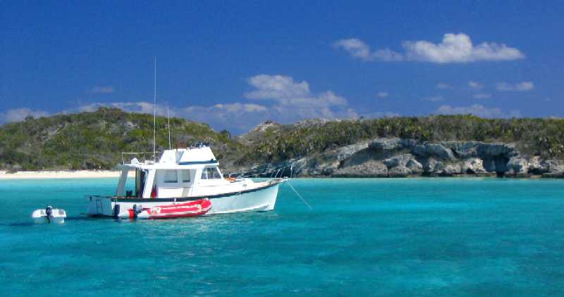
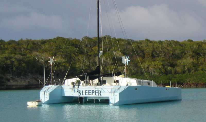
Rather than follow our plan, which had us going to Little Farmer's Cay yesterday, we instead followed three other boats (two with kids) to Galliot Cay, just south of Little Farmer's, to hang out with them. We would not have seen Galliot otherwise, and we're glad we went, it was a lovely spot. In addition, it fed us. Steve and Angie, from the very unusual home-built catamaran Sleeper (below), and Bob, who lives aboard the Endeavor 40 See World with his wife Trisha and children Bobby (5 1/2) and Genna (3), went spear fishing in the afternoon and caught a boatful of lobster, red snapper, and grunt. Everyone in the anchorage got free fish. We got a snapper and a small lobster, which was perfect for us since Tania won't eat fish and we can't refrigerate it. It was very good.
Being there also gave us a chance to consult with Steve on the inflatable dinghy repair, which was another good thing. Steve is an RC model airplane enthusiast, and he builds them on board Sleeper (which is something like 60 feet long and 35 feet wide and has LOADS of room). Turns out he does ALL his gluing with either straight liquid superglue or superglue gel (which sets more slowly), and he's had LOTS of experience repairing, even completely rebuilding, inflatable dinghies with the stuff. His opinion: "The only difference is that with superglue you're back on the water in fifteen minutes." Since our problem was that the rubber part in which one of the inflation valves is embedded was riddled with cracks (after 20 years of UV and ozone) and leaking air, and needed some sort of infusion of liquid that would solidify in place and make the rubber solid again -- sort of like Git-Rot does for rotted wood: it seeps in, fills all the voids, and cures in place -- this superglue approach looked promising, especially when Steve handed Lane a fresh tube for the purpose.
Sleeper
Well, now it's a day later, and we have to say that this repair had no right to go as well as it did. Consisting of three operations -- the rubber infusion, the application of an annular reinforcing patch around the valve (to cover and "sandwich" the rubber), and the gluing down of the valve clamp ring (it will NEVER come out of there short of cutting it out) -- the repair took longer than the advertised 15 minutes. It took 30 -- including the time to precision-cut the ring-shaped patch. Lane was so skeptical of the simplicity of the process ("It can't be ready to inflate yet!") that we left it overnight, inflated it lightly this morning, towed it to the beach behind the hard dinghy, reassembled it, slightly increased the air pressure, and towed it all day behind Wind Song with no load in it. We'll check it again tomorrow, and if it still hasn't leaked, maybe we'll move on to actually sitting in it.
If this ends up working, it
will be a miracle. You should have seen that rubber piece. It looked like
tissue paper.
24° 12.55'N, 76°
28.45' W
Sampson Cay
February 19, 2005
Well, Sampson Cay Marina & Resort, from which we are now anchored possibly 300 feet away, has wifi too, and we're sitting out a front here as well, so maybe it's time to finish this report and get it sent.
The headline news is, the dinghy is holding air -- hasn't leaked one bit as near as we can tell -- but Lane is still uneasy. He can't believe that mess of a valve substrate can possibly be held together by two grams of dime store glue. Doesn't "pass the giggle test", as they say where he works. He might believe it in a week or two, after it's been thrashed around a bit.
Next news: the weather is really settling down. This front today, which is as severe as we've seen in 2-3 weeks, is not much to be bothered by, and right now it is "stalled out and dissipating". It started last night at 0230 with some light rain, settled in to about 15-20 knots of NE'ly wind by dawn, and is now (1006) blowing E perhaps 10-15 knots. This is a bulletproof hole for winds from N-E-S, so we're snug as a bug and not complaining, taking advantage of this "indoors" day to get some work done. Roxanne's working her college financial aid issues via Internet, Tania's doing schoolwork, and Lynn's getting ready to email a guy in Oxford, MD we heard about who may be able to advise us on how best to sell Wind Song in the Chesapeake area. We'll be on our way tomorrow morning as the wind goes SE and stays there for 2-3 days, probably with clear skies.
One of the things we've been learning around here is not to snorkel anywhere near a marina, or anywhere else where fish are cleaned. All the detritus goes directly into the water, where a small hoard of scavengers and predators gathers regularly in the late afternoon for the handouts. Sharks and rays predominate, with the occasional barracuda and a few horsehide jack (which are carnivores). The problem is, when it is not "feeding time", all these guys hang out in the surrounding waters waiting for the afternoon glut. The sharks lie on the bottom and appear to sleep, which is OK cuz they're clearly visible, but the rays do the same thing, except burrowed under a thin layer of sand where they are not easily seen. One thing you don't want is to step on a ray with a four or five foot wingspan and get stung in the ankle. "Stung" is too mild a word. If it happens, it's hospital time, with air evacuation to Nassau or Florida, and possibly being partially crippled the rest of your life.
We forgot to mention, back at Staniel Cay there are three small cays, really just rock islands that stick straight up out of the water about 20 feet, lying in a string north of the resort, and we were anchored on the sand bank just east of the third one. On the north end of this cay/rock is a jumble of large rocks that clearly used to all be together and part of the cay but got undercut by wave action and fell off, and if you snorkel through the rock jumble you find yourself in a large grotto, about 10-12 feet deep with coral and lots of fish, and with a ceiling 20 feet overhead that is open to the sky in a few places. There are also good-sized underwater entrances to the area. A fantastic place, really beautiful, and very unusual -- a real find, you'd think, but you would not be alone. The makers of the James Bond movie Thunderball discovered it in 1964, and the cave is in the movie. In the Staniel Cay Yacht Club bar there are pictures of the actors and film crew bellied up to the bar eating and drinking, including the guy with the eye patch who played the "bad guy" -- but none of Sean Connery. There are two dinghy moorings off the cave entrance, which is seldom enough. In settled weather there are always five or six dinghies anchored there, and small but crowded tourist boats come across the 1/4 mile or so from the marina with loads of pale-skinned vacationers, some of whom can't even swim, but with the help of a tightly buckled life jacket they're in there too, by god, with reef walkers on their feet instead of swim fins, thrashing their legs uselessly, soaking up the tropical ambience amid secret agent fantasies. From underwater through a dive mask they seemed like another weird species of water creature, part of the scenery, just harder to swim around because they didn't get out of the way like the fish do.
Our "initerary" is kind of a joke right now. We fill in what has already happened, so that part is nice and crisp, then we see what can be accomplished in the remaining time, and watch the latter shrink as the weeks go by with nothing happening. Now that we're out of Georgetown we've actually been staying more or less on track, maybe even ahead of schedule. If this trend holds, we'll spend another two weeks in the Exumas going north, then stop in Nassau for fuel, water, groceries, and CASH. We made a mistake paying cash in Staniel Cay for fuel, water, and a lunch in the restaurant before discovering there are NO BANKS between Georgetown and Nassau and almost no one takes VISA (Staniel Cay does . . . ) -- and with water at 40 cents/gallon, using 6 gallons a day, and only $45 cash remaining in our wallet, that's 18 days, which is tight. After five days in Nassau we'll head north for the Abaco Cays, followed by the rarely-visited Bight of Abaco (an area with no settlements, no people, and no services -- read: water), and then back to Florida. The current plan has us within driving distance of Fort Lauderdale (say, Palm Beach/West Palm area) with eight days of slack against our self-imposed deadline of April 27th, which gives us five days to find a place to hole up, get a car, and get Tania on a plane for CA on May 2nd so she can take her AP exams. In other words, we have 67 days remaining in the Bahamas, of which 59 are planned.
By the way, you'd think that with all this talk of water, of which we can carry at most a 10 day supply, we'd have a watermaker on board. Well, we did have one last time. It cost $2000, it stopped working after it had made 1000 gallons of water, and none of our attempts to service it made it work again. That's easy math: $2 a gallon, not counting what it took to generate the extra electricity to make it run -- which Wind Song does not have. Makes paying 40 cents a gallon at marinas look pretty darn good. We decided to pass. If we can just remember to keep enough cash on hand . . .
That's it for now. Hope you all are well and doing fine. Life is good here. We're all getting over a cold that Roxanne caught first, that is slowing us down a bit, but that's blowing through just like the fronts, and will soon be past. And this place continues to be jaw-droppingly beautiful everywhere we go.