Update 13
Monday 6/8/2009
Day 47 (18 days to Lynn's arrival)
Imlay City, MI to Suttons Bay, MI, 235 miles
At the end of the last update I was in Imlay City, MI and you read these words:
"Tomorrow, however, is not looking good: 70% chance of rain throughout the day. 240 miles. Could be a test of my stamina."
To say the least. I woke up at 5 am in the seedy but inexpensive M53 Motel in Imlay City, looked out the window, and saw that the pavement was still dry. Barely. Since the only thing worse than driving a motorcycle in the rain is sitting still on one in the rain, or loading one, I packed immediately, garbed myself for the onslaught, and headed out. The first 150 miles was on interstate highway, the rest on fast two-lane roads with slowing through towns.
Not to mince words, I froze my a** off, plus scared the cr*p out of myself in a near-spinout at 60 mph with a semi bearing down from behind.
At first the rain was mild, then moderate. Then . . . well, it got a lot worse. I persevered for 15-20 minutes but finally decided to pull off under an overpass to check things out and just sort of collect my wits. This worked fine. The bike was working fine, everything that was stowed was surviving, and I hadn't gotten *too* wet (yet). Biggest problem was cold: It was 49-50 degrees.
Then I got ready to pullback into traffic -- heavy Monday morning traffic between Flint and Saginaw. Then I saw that, due to a lack of foresight on my part, I was on a slight right-hand curve, which meant the oncoming traffic in my left rearvew mirror did not appear until it was actually a little too close to accelerate in front of. Not to mention the mirror was covered with rain and tire spatter from the trucks passing me at 70 mph, so I couldn't see much anyway..
I snicked the bike into second gear -- I always take off in 2nd on the flat, 1st being really a granny gear for hills, and 2nd is good for 60 mph at redline. I waited patiently for the "opportune moment" (as Johnny Depp would say as Captain Jack Sparrow) and took my shot. Just as I pulled out a truck appeared around the bend, so I rolled on as much throttle as I thought the traction conditions would allow, but the truck was still gaining when I was at 60 mph and redline. So I did what I always do in such situations: snap-shifted to 3rd. I mean, that bike will out-accelerate anything.
Instead of accelerating, the rear tire broke traction, the tachometer hit the rev limiter at 6000 rpm (so the tire was doing 80), and the rear end was all over the place. I somehow had the presence of mind not to roll all the throttle off abruptly, and reminded myself while so doing that the worst part would be the snap-back as the rear end regained traction and whipped into line. When it happened it happened HARD. I'd been steering into the skids, and somehow didn't lose it when it came back. Then I had to summon the will to get back on the throttle before being converted to jerky by the truck. I think the distance between us got down to about 50 feet. Not enough for him to have missed me had I fallen.
To keep from dwelling on the incident, my mind yelled "Just drive, dammit!" and so I did. No harm no foul, as Chick Hearn used to say. Put it behind you. What the hell, only 200 more miles to go.
Which brought me to the next challenge: hypothermia.
I will simply say that I did not have enough clothing for those conditions. I had not had any breakfast, and I was shivering uncontrollably, so my next move was to stop under cover in a gas station adjacent to a restaurant, got permission to just leave my bike on the gas island, and ordered breakfast. Including carbs (potatoes and toast). Then I went into the men's room and donned long underwear bottoms beneath my jeans and rain pants (I did not bring a top, thinking my jacket liner would be enough), and headed out into it again.
The next two and a half hours consisted of driving 30 minutes and then stopping for coffee, repeatedly. Finally the rain eased back a bit, the temperature crept up to 56-57, and I reeled off the last 20 miles with relative ease. The food helped a LOT.
My uncle Don and Aunt Joyce met me with smiles on the front porch of their home on the shore of Grand Traverse Bay (off the NE corner of Lake Michigan), I disrobed and hung up all my wet things, and had more coffee. Still mildly hypothermic, I did not take my jacket liner off all evening.
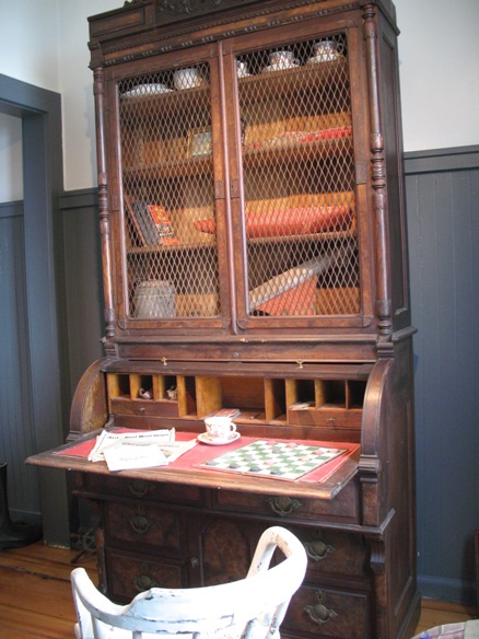
I guess you'll understand why there are no pictures of this day.
Tuesday 6/9/2009
Day 48 (17 days to Lynn's arrival)
Suttons Bay, MI & environs
Morning dawned cold and threatening, but since all activities for the next five days would involve automobile transportation, I wasn't worried.
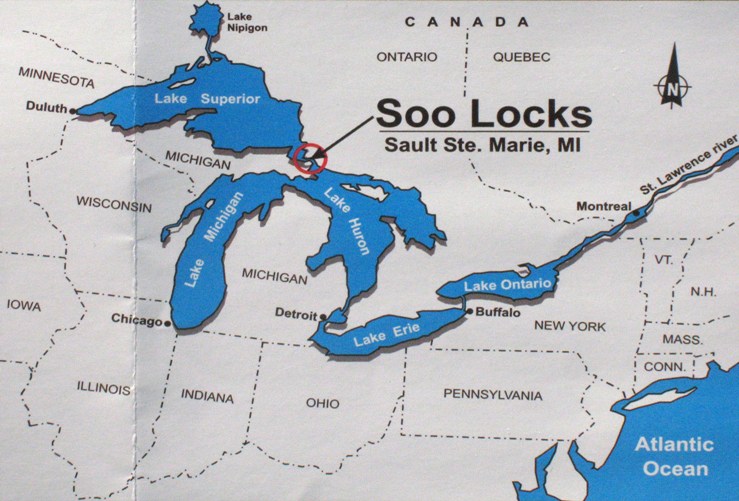
Let's start with a couple maps. Here's the northern Michigan area.
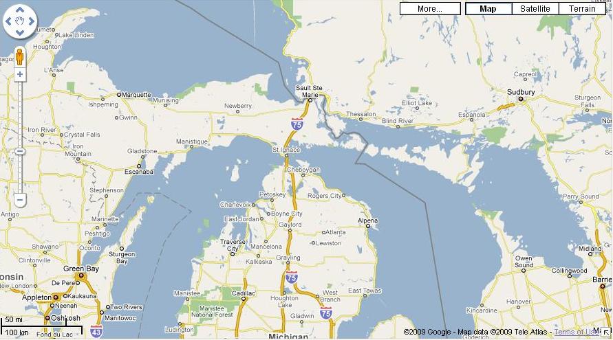
That's Lake Superior upper left, Lake Michigan center left, and Lake Huron center-right. The strait connecting Lakes Michigan and Huron, center, where it says "St Ignace", is the Strait of Mackinac (pronounced "MACK in awe"). The strait connection Lakes Superior and Huron, upper center where it says "Sault Ste Marie", is, um, Sault Sainte Marie. Sault is pronounced "SOO" and means "rapids" or "cascade" in French. On both sides of that strait there is a town called Sault Sainte Marie, one in Michigan and one in Ontario, Canada.
South and west of Mackinac the large bay cut southward into the NW Michigan shoreline is Grand Traverse Bay, with Traverse City at it's southern end. Here's a blow-up.
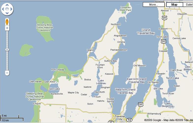
Grand Traverse Bay is 33 miles long. The southern half of it is bisected by the Mission Peninsula, producing a West Arm and an East Arm of the Bay. Don and Joyce's summer house is on the west shore of Suttons Bay, near the top of the West Arm, just north of the words "Suttons Bay" at the center of the map. This was our base of operations.during my visit.
Notice that in this area there are lots of long, skinny bodies of water that run north-south. This makes east-west travel rather aggravating.
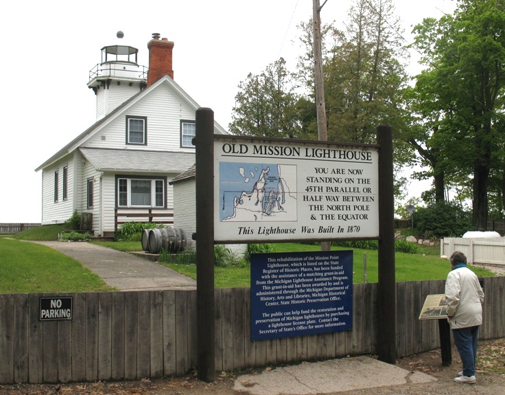
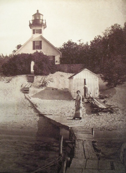
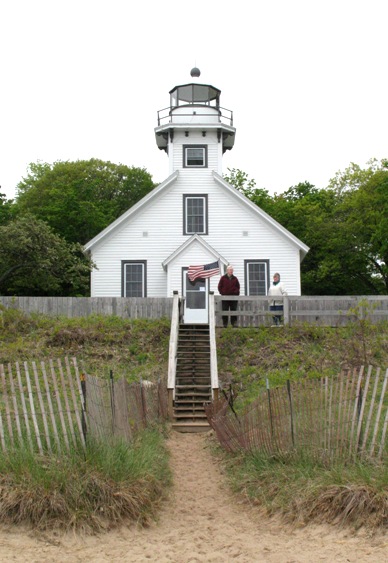
On this first day we toured the Mission Peninsula all the way to the Old Mission Lighthouse at its tip. We then went southwest to Interlochen, a high school for the arts located SW of Traverse City, off the map above.
Despite what it says on the sign, truthfully Joyce is NOT standing on the 45th parallel in this photo. Folks up there are pretty free with their interpretation of its location. It's actually in the water about a hundred yards past the lighthouse.
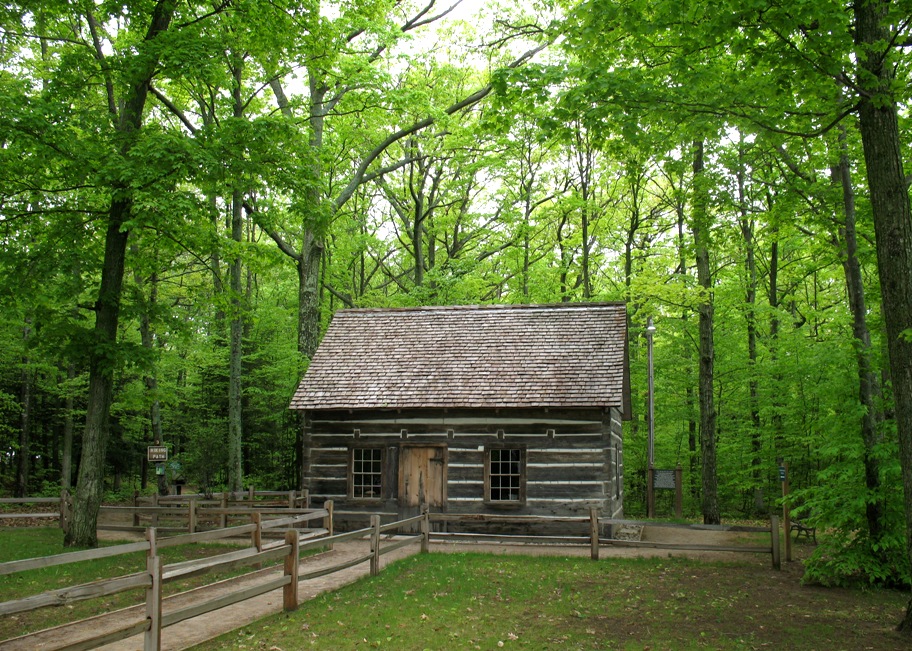
Nearby was this historic log cabin (called the Hesler Log House). It was built about 14 miles south of here by Joe and Mary Hesler, he from Canada and she from Ireland, over the period 1854-56, one of the earliest homes in the area. It was moved here for preservation.
The Lighthouse Keeper's office. Note that in the cabinet there are three unfinished hulls of sailboat models, one intended to actually sail (the one at the bottom with the deep keel). These actually belonged to the last Keeper. Apparently a Lighthouse Keeper's duties were not all-consuming.
Not all Lighthouse Keepers were men. This lady was one. On the right, the present-day structure for comparison.
From here we drove to Interlochen, so named because it lies directly between two lakes. In addition to a State Park, there is also a world-famous school for the arts here, the self-proclaimed "world's first and foremost fine arts boarding high school". Here's a view up Eugene Ormandy Avenue (he's a famous music composer and conductor), with girls' dorms on both sides (the boys' dorms are elsewhere).
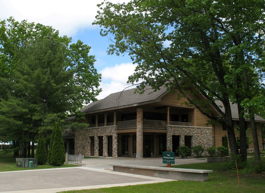
Near the northern end of E.O. Ave is The Writing House, the center for creative writing. The use of river stones and native woods in construction is common throughout the campus.
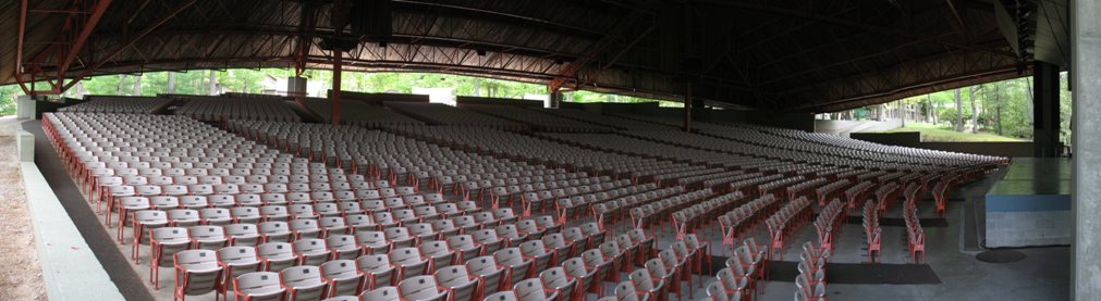
There are several auditoria on campus, as you'd expect, but this one is noteworthy for its size (4000 seats), for the fact that it is open-air, for the fact that the roof has only two supporting pillars other than those at the edges . . .
. . . and for the fact that the stage is open to the lake in back.
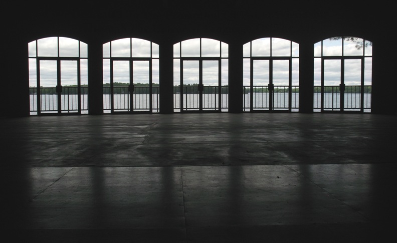
Right outside those windows you find this scene.
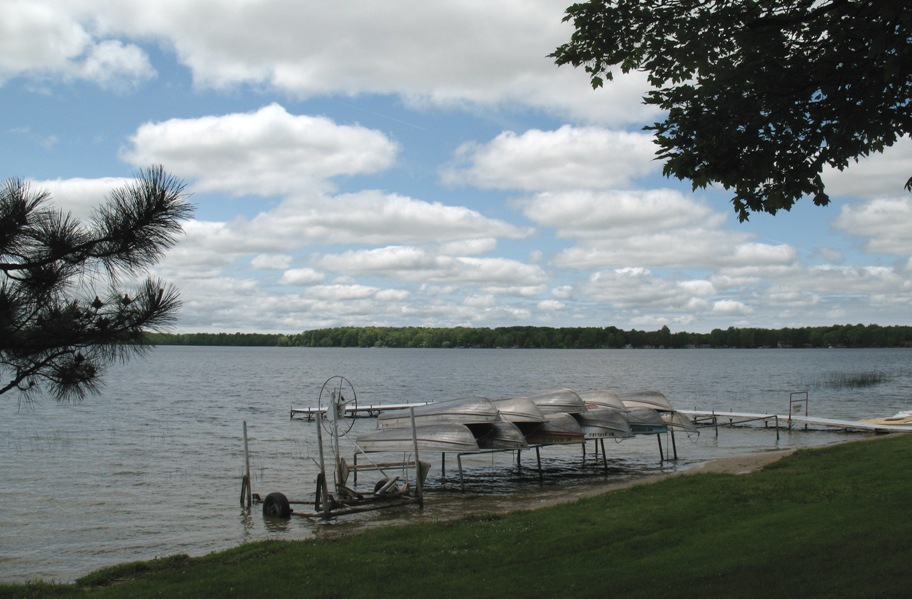
Pretty idyllic, I'd say!
Wednesday 6/10/2009
Day 49 (16 days to Lynn's arrival)
Morning dawned cold and threatening again. This was to become a theme. This photo captures the few seconds of sunlight that appeared at sunrise.
Ten minutes later it looked like this.
By midday, and 125 miles farther north, it actually cleared up to become a fine day. By that time we were at the Mackinac Straits to view what is known in my family as Grandpa's Bridge. I'm going to show you five views. You may think that is excessive, but believe me it is nothing compared to what's decorating the walls of the downstairs level of Don and Joyce's house (the walls of which are adorned only with bridge photos, in every imaginable season, weather, time, and circumstance), not to mention just about every public establishment (restaurant, bar, real estate office) within a hundred miles. I mean, it's a popular subject. Here they are.
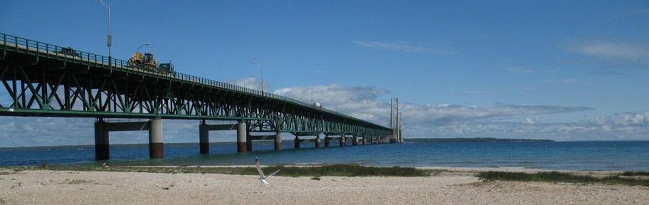
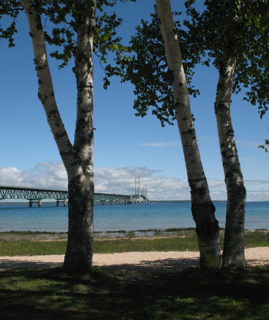
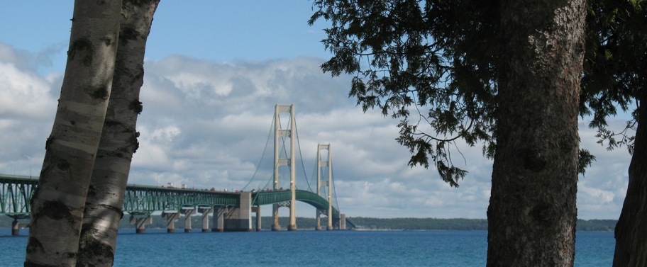

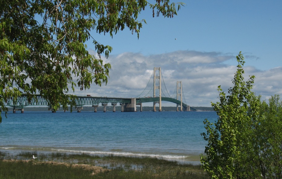
These are all taken from different locations within a single hundred-yard stretch of shore SE of the bridge.
Now, kidding aside, you have to remember that Michigan is split into two parts, the main (southern) part and what's called the Upper Peninsula, which is what's across that bridge in these photos. And the quickest way to get from one side of this strait to the other, absent this bridge or a ferry (which couldn't run in winter) is 876 miles via Chicago. According to Google Maps that's 15 hours 17 minutes of driving on today's roads in today's cars.
So there were folks back then (before 1957 when the bridge opened) who really wanted a bridge, but the Michigan government didn't want to spend the money -- or even risk the money assuming tolls would pay back the construction cost. The Feds wouldn't help either. Finally Michigan formed the Mackinac Bridge Authority to sell unsecured bonds (no "full faith and credit" guarantee) to finance the bridge, about $100M worth, which was reduced to $96,400,033.33 after various financiers and securities companies got their cut. I know this number because of this photo of the actual check that, when deposited, allowed construction to begin.
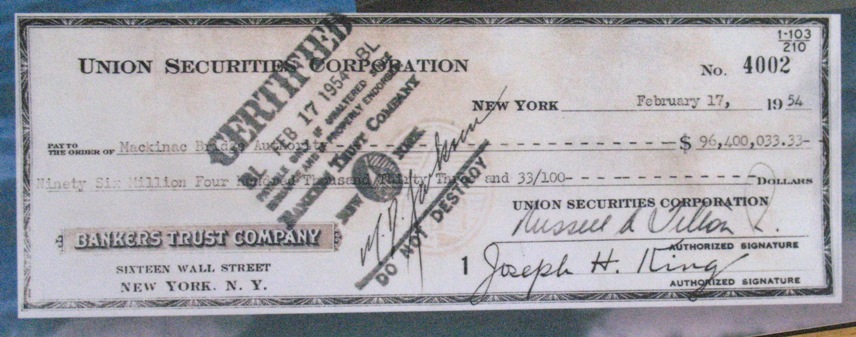
Why is this important to the Darnton family? Because this check had to be deposited in a bank somewhere, and that bank would act as the Fiduciary Agent for the Mackinac Bridge Authority, i.e. all interest accrued and payouts made would go through that bank. And that bank was the Detroit Bank and Trust Company.
In the ceremony that attended the transfer of these funds to the Detroit Bank and Trust Company, shown here . . .
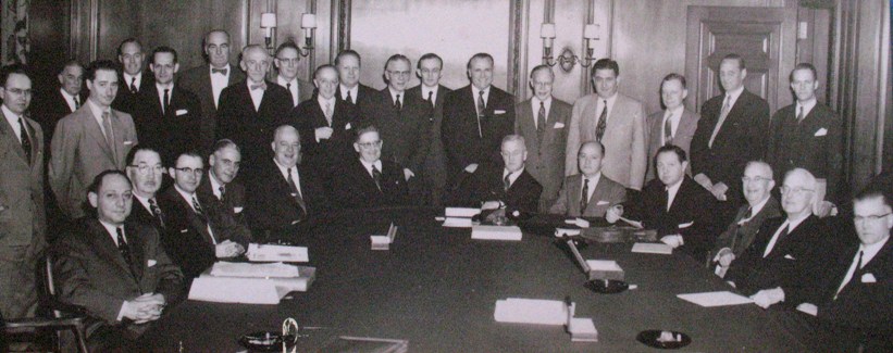
. . . you will see a somber guy with dark hair, in a dark suit, seated at the table third to the right of center, with the check in his hand. That man is Lawrence Rubin, Secretary to the Mackinac Bridge Authority. Seated to his left (your right) is a man with by far the biggest smile in the room. He was the Vice President for Trusts of the Detroit Bank and Trust Company. It would be his job to manage these funds.
That man is my grandfather, Mr. C.T. (Tom) Darnton.
Moving on now to Sault Sainte Marie. This map will help.
Here's what you need to know. The manufacture of steel requires iron ore, limestone, and coal for heat. The ore comes from places like Minnesota, northern Wisconsin, and the Upper Peninsula of Michigan. Right at the center of ths area is Duluth, MN, on Lake Superior. But this ore needs to be shipped to the foundries, which are where the coal is, in places like Ohio, Pennsylvania, and western New York, an area centered on Lake Erie. And the cheapest, easiest way ship it is by boat.
Only one problem: Lake Superior is 21 feet higher than Lake Huron, and that 21 foot drop occurs at (and is named) Sault Sainte Marie. The rapids there -- really a cascade -- is called the St Marys Falls. And ships can't go down them.
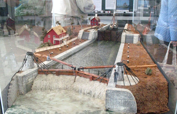
So, boys being boys, soon you've got a rudimentary two-lock system (shown here in a model) for small sailing ore carriers.
Given time (and the avid involvement of more people with Y-chromosomes), you get this.
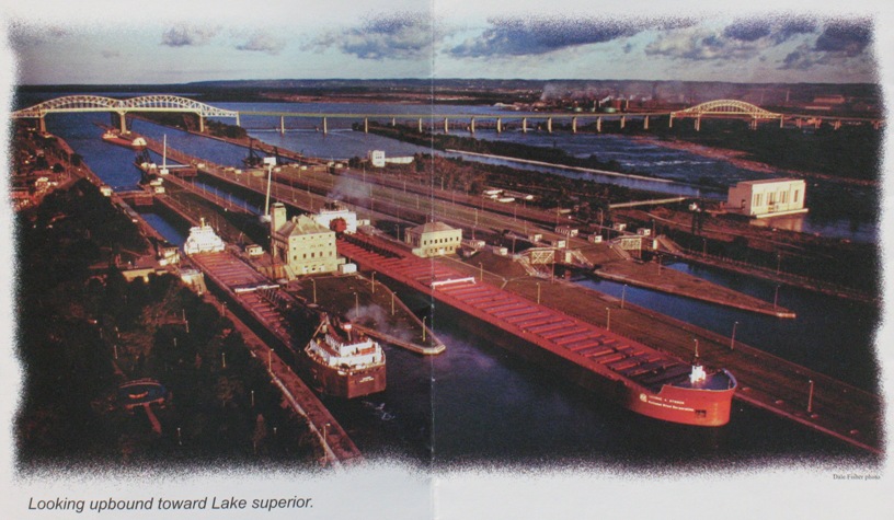
These locks are 1300 feet long and 80 feet wide, and the job is done in one drop, not two, because 21 feet is well within modern lock engineering capabilities. But it's the whole system that's really impressive. Take a gander at this.
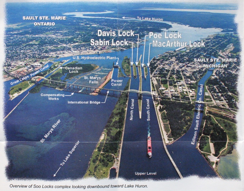
This requires explaining. I'll try to be brief. Here's the short version: not one drop of this water goes down the 21 feet from Lake Superior to Lake Huron without human permission. To elaborate: There are five locks, four on the US side (operating) and one on the Canadian side (defunct). Each operates via water flowing downhill. Then there are three canals, left to right: the Great Lakes Power Canal feeds a Canadian hydroelectric power plant, the U.S. Hydroelectric Plant feeds power to the locks themselves, and the Edison Sault Electirc Co. Canal feeds a US hydroelectric plant.
That leaves only the Falls, water to which is controlled by the Compensating Works, a set of gates that allow water to go down St Marys Falls ONLY IF no one else wants or can use it.
And to add insult to injury (viewed from the standpoint of river ecology), it should be obvious that a hydroelectric plant (which is where most of this water is going) takes energy out of the water. Half of it, in fact (due to a little-known mathematical tidbit called the Virial Theorem, one of the few bits of my Physics education I remember). Which means the water coming out the other side is going about 29.3% slower. Do you think this could have an impact on sedimentation rates, aquatic vegetation, fish, and such?
OK, that load of info ought to hold you for a day. Tomorrow -- well, I don't know where you'll be, but tomorrow is Day 55 in my world, and in all likelihood I'll spend it riding 219 miles from Ashland, WI to Bemidji, MN -- in the rain. Not a happy thought.